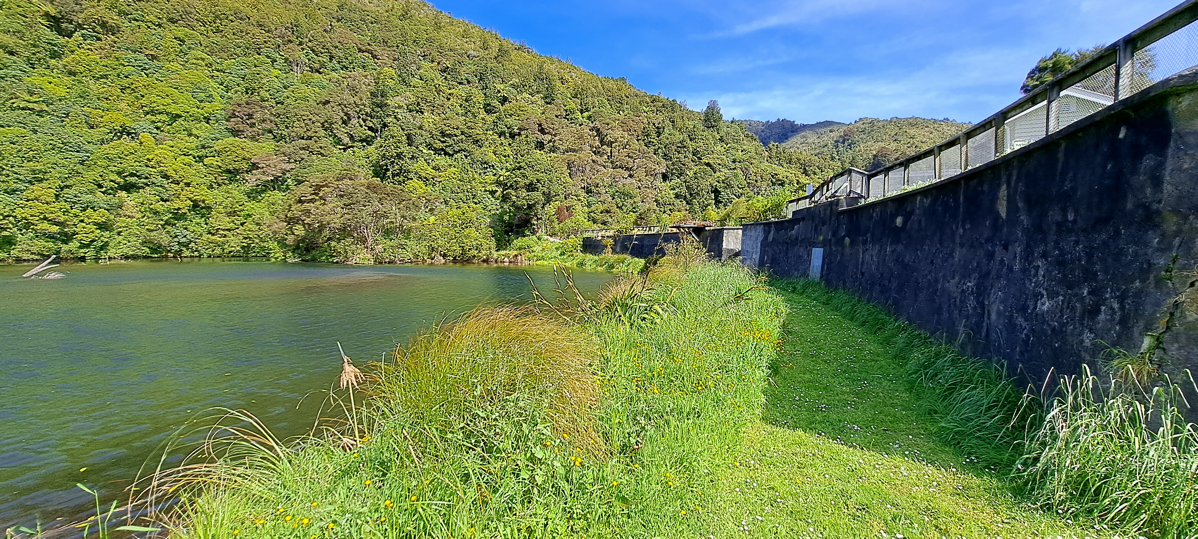
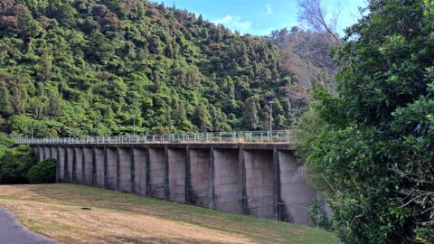
View of the decommissioned Wainuiomata Lower Dam (named Morton Dam). This dam once supplied water to Wellington along with another dam in the Wellington suburb of Karori. A new dam in Wainuiomata behind the lower dam was built and is still in use today.
ALL / Explore Oceania / Explore New Zealand / New Zealand Photos / Wainuiomata photos / Wainuiomata Lower Dam
All original royalty-free photos, shareable maps, and informative articles.
Wainuiomata Lower Dam
Page Views
This post has been viewed 751 times
Related Articles
-
Queen Street Reserve in Fall
Wainuiomata photos, Autumn, Portrait / Vertical, Trees
Observing Queen Street Reserve in the fall, you’ll find a charming oasis nestled in the heart of the Wainuiomata...
-
Richard Prouse Park & Cricket
Wainuiomata photos, Extra Wide Horizontal, Mountains, Sport
Summer at Richard Prouse Park in Wainuiomata. The park is used for the game of cricket during the summer...
-
Sledge Track Creek
Wainuiomata photos, Cities, Harbors, Landscape / Horizontal, Mountains, Night
The Sledge Track Creek in Wainuiomata offers a scenic view, winding through dense native bush with an old forestry...
-
Wainuiomata River and Regional Park
Wainuiomata photos, Extra Wide Horizontal, Mountains, Rivers
Looking at Wainuiomata River within Wainuiomata Regional Park. Also in view is the Remutaka mountain range.
-
Wainuiomata Recreational Area Museum
Wainuiomata photos, Extra Wide Horizontal, Homes, Museums
View of the museum in the Wainuiomata Recreational Area. This house among others originally homed workers at the dam.
-
Remutaka Hills Wainuiomata
Wainuiomata photos, Extra Wide Horizontal, Forests
Looking at a forested foothill in the Remutaka Range. The Lower Hutt suburb of Wainuiomata is set below these...
-
Parched Farmland in Wainuiomata
Wainuiomata photos, Extra Wide Horizontal, Roads, Rural
Gazing upon parched farmland during the summer months, situated along the Coast Road in Wainuiomata, New Zealand.
-
Ravine Near Sledge Track Creek
Wainuiomata photos, Ferns, Forests, Portrait / Vertical
A ravine close to Sledge Creek Track in Reservoir Valley in Wainuiomata. The area is covered in podocarp rainforest...
0 Comments
Calendar
M | T | W | T | F | S | S |
---|---|---|---|---|---|---|
1 | ||||||
2 | 3 | 4 | 5 | 6 | 7 | 8 |
9 | 10 | 11 | 12 | 13 | 14 | 15 |
16 | 17 | 18 | 19 | 20 | 21 | 22 |
23 | 24 | 25 | 26 | 27 | 28 | 29 |
30 |
Popular Posts
- Awakening New Zealand video (100)
- Iguazu Falls as seen from Brazil (87)
- Metrocable Medellin (78)
- Pauatahanui Inlet (69)
- Spinnaker Hill View (68)
- Spinnaker Hill in Whitby Porirua (68)
- View from Whitby (68)
- The Devil’s Throat (62)
- Aerial View of Iguazu Falls (61)
- Porirua Harbour & Papakowhai (57)
- Lake Wakatipu (57)
- Salto Rivadavia & Iguassu River (56)
- Lake Tekapo & Lupins (54)
- Nelson View (53)
- Salto Rivadavia Misiones Province (53)
- Cascadas at Iguazu (53)
Subjects
AccommodationAnimalsArchitectureBeachesBirdsBoatsBridgesBuildingsCarsChurchesCitiesCoralCultureExtra Wide HorizontalFlowersForestsHarborsHomesIslandsLakesLandscape / HorizontalMapsMenMonumentsMountainsPalmsParksPeoplePlantsPortrait / VerticalRiversRoadsRuralSeaShopsSkyscrapersSnowSunsetsTownsTrailsTransportTreesVideosVolcanicWaterfalls
Recent Comments
- Lance on Concrete Hut Wainuiomata
- Tony on Concrete Hut Wainuiomata
- DavidJ on Wellington Night Skyline
- Ben on Auckland City Skyline from Westhaven Marina in 1998
- Ben on Auckland Harbour Bridge view