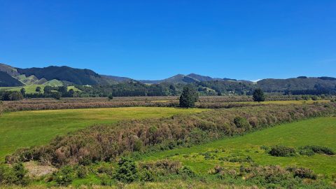
Viewing several farmhouses in Whitemans Valley near Upper Hutt. The valley is predominantly rural, with a number of connecting roads providing access to the more urbanised Hutt Valley.
ALL / Explore Oceania / Explore New Zealand / New Zealand Photos / Upper Hutt photos / Whitemans Valley Farm Houses
All original royalty-free photos, shareable maps, and informative articles.
Whitemans Valley Farm Houses
Page Views
This post has been viewed 256 times
Related Articles
-
Whitemans Valley from Wallaceville Road
Upper Hutt photos, Extra Wide Horizontal, Rural
Looking down over the rural landscape of Whitemans Valley, situated east of Upper Hutt. The photograph was taken from...
-
Aston Norwood Gardens Path
Upper Hutt photos, Autumn, Landscape / Horizontal, Trees
View of the path that descends into the gardens at Aston Norwood near Upper Hutt. The gardens are a...
-
Maidstone Park Walks
Upper Hutt photos, Extra Wide Horizontal, Forests, Parks
This path offers several small tracks that take you through the bush and up to the ridgeline, where you...
-
Silverstream McDonald’s Destroyed by Fire
Upper Hutt photos, Buildings, Fire, Landscape / Horizontal
Silverstream McDonald’s in Upper Hutt was destroyed by fire in 2016. A new McDonald’s was promptly built on the...
-
Upper Hutt from Wallaceville Road
Upper Hutt photos, Aerial, Extra Wide Horizontal
Looking down over Upper Hutt from Wallaceville Road, which leads to Whitemans Valley. Maidstone Park is visible on the...
-
Stuart Macaskill Lakes in Te Mārua
Upper Hutt photos, Lakes, Landscape / Horizontal
Stuart Macaskill Lakes supply drinking water to the Hutt Valley, Porirua, and Wellington. The lakes were named after a...
-
Silverstream Pipe Bridge
Upper Hutt photos, Bridges, Extra Wide Horizontal
The Whakawhirinaki Silverstream Pipe Bridge is a new infrastructure project spanning the Hutt River in the Lower Hutt region...
-
Upper Hutt Aerial View
Upper Hutt photos, Aerial, Cities, Extra Wide Horizontal, Mountains
A cloudy day at Upper Hutt as seen from the western hills. The Hutt River and State Highway 2...
0 Comments
Popular Posts
- Awakening New Zealand video (100)
- Iguazu Falls as seen from Brazil (87)
- Metrocable Medellin (78)
- Pauatahanui Inlet (69)
- Spinnaker Hill View (69)
- Spinnaker Hill in Whitby Porirua (69)
- View from Whitby (68)
- The Devil’s Throat (63)
- Aerial View of Iguazu Falls (61)
- Porirua Harbour & Papakowhai (58)
- Lake Wakatipu (57)
- Salto Rivadavia & Iguassu River (56)
- Salto Rivadavia Misiones Province (54)
- Close up of Salto Rivadavia (54)
- Cascadas at Iguazu (54)
- Lake Tekapo & Lupins (54)
Subjects
AccommodationAnimalsArchitectureBeachesBirdsBoatsBridgesBuildingsCarsChurchesCitiesCoralCultureExtra Wide HorizontalFlowersForestsHarborsHomesIslandsLakesLandscape / HorizontalMapsMenMonumentsMountainsPalmsParksPeoplePlantsPortrait / VerticalRiversRoadsRuralSeaShopsSkyscrapersSnowSunsetsTownsTrailsTransportTreesVideosVolcanicWaterfalls
Recent Comments
- DavidJ on The True Size of Australia
- Anonymous on The True Size of Australia
- Lance on Concrete Hut Wainuiomata
- Tony on Concrete Hut Wainuiomata
- DavidJ on Wellington Night Skyline