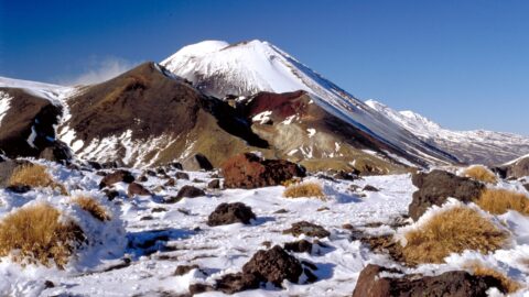
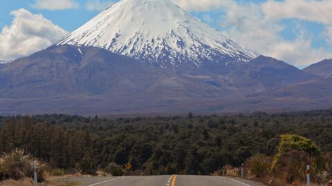
Mount Ngauruhoe is surrounded by tussock plains on the east and western sides. This view is seen from State Highway 1 on the eastern side of the peak.
ALL / Explore Oceania / Explore New Zealand / New Zealand Photos / Tongariro National Park photos / Mount Ngauruhoe & Tussock Plains
All original royalty-free photos, shareable maps, and informative articles.
Mount Ngauruhoe & Tussock Plains
Page Views
This post has been viewed 453 times
Related Articles
-
Mount Ngauruhoe View
Tongariro National Park photos, Landscape / Horizontal, Mountains, Snow, Volcanic
View of Mount Ngauruhoe and surrounding tussock hills in New Zealand’s Tongariro National Park. The volcano is an almost...
-
Native Forest on Ruapehu
Tongariro National Park photos, Forests, Landscape / Horizontal, Plants
While much of the landscape around Mount Ruapehu consists of low scrub and tussock, there are also some tracts...
-
Mangawhero Falls Walk
Tongariro National Park photos, Landscape / Horizontal, Mountains, Snow, Volcanic, Wetlands
This section of the Mangawhero Falls Walk uses a boardwalk in order to navigate an area of tarns. Tarns...
-
Forest Walk on Ruapehu
Tongariro National Park photos, Forests, Landscape / Horizontal, Plants
Below Mount Ruapehu and on the lower flanks are areas of native forest. There are a number of trails...
-
Ohakune Mountain Road View
Tongariro National Park photos, Landscape / Horizontal, Mountains, Roads, Snow, Volcanic
Driving up Ohakune Mountain Road with the snow capped peak of Ruapehu in view. The road starts near the...
-
Mount Ngauruhoe & Highway
Tongariro National Park photos, Landscape / Horizontal, Mountains, Snow, Volcanic
Mount Ngauruhoe comes into view on State Highway 47 in Tongariro National Park. The volcano is part of the...
-
Ruapehu Peak View
Tongariro National Park photos, Landscape / Horizontal, Mountains, Roads, Snow, Volcanic
The snow capped peak of Mount Ruapehu can be seen clearly above areas of forest, tussock, and ancient lava...
-
Ohakune isite Visitor Information Centre
Tongariro National Park photos, Buildings, Landscape / Horizontal
The Ohakune isite Visitor Information Centre specialize in local insights and advice for travelers exploring the Ruapehu region. They...
0 Comments
Calendar
M | T | W | T | F | S | S |
---|---|---|---|---|---|---|
1 | ||||||
2 | 3 | 4 | 5 | 6 | 7 | 8 |
9 | 10 | 11 | 12 | 13 | 14 | 15 |
16 | 17 | 18 | 19 | 20 | 21 | 22 |
23 | 24 | 25 | 26 | 27 | 28 | 29 |
30 |
Popular Posts
- Awakening New Zealand video (100)
- Iguazu Falls as seen from Brazil (87)
- Metrocable Medellin (78)
- Pauatahanui Inlet (69)
- Spinnaker Hill in Whitby Porirua (68)
- Spinnaker Hill View (68)
- View from Whitby (68)
- The Devil’s Throat (62)
- Aerial View of Iguazu Falls (61)
- Porirua Harbour & Papakowhai (57)
- Lake Wakatipu (57)
- Salto Rivadavia & Iguassu River (56)
- Lake Tekapo & Lupins (54)
- Nelson View (53)
- Salto Rivadavia Misiones Province (53)
- Cascadas at Iguazu (53)
Subjects
AccommodationAnimalsArchitectureBeachesBirdsBoatsBridgesBuildingsCarsChurchesCitiesCoralCultureExtra Wide HorizontalFlowersForestsHarborsHomesIslandsLakesLandscape / HorizontalMapsMenMonumentsMountainsPalmsParksPeoplePlantsPortrait / VerticalRiversRoadsRuralSeaShopsSkyscrapersSnowSunsetsTownsTrailsTransportTreesVideosVolcanicWaterfalls
Recent Comments
- Lance on Concrete Hut Wainuiomata
- Tony on Concrete Hut Wainuiomata
- DavidJ on Wellington Night Skyline
- Ben on Auckland City Skyline from Westhaven Marina in 1998
- Ben on Auckland Harbour Bridge view