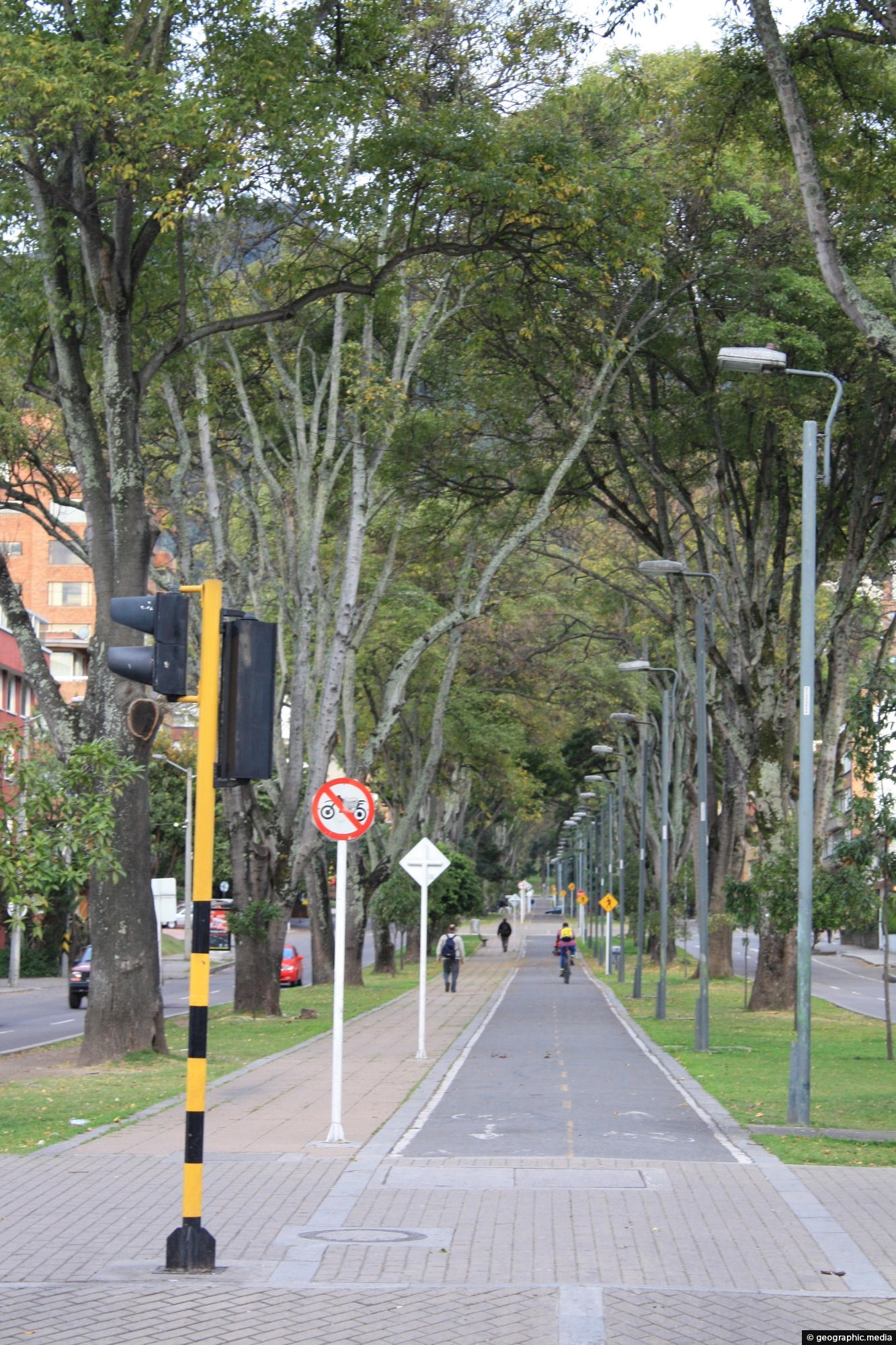
Bogota city in Colombia has around 550 kilometers (340 miles) of cycleways making it one of the most extensive bicycle networks in the world.
ALL / Explore South America / Explore Colombia / Colombia Photos / Bogota photos / Cycleway in Chapinero Bogota
All original royalty-free photos, shareable maps, and informative articles.
Cycleway in Chapinero Bogota
Page Views
This post has been viewed 359 times
Related Articles
-
National Museum of Colombia
Bogota photos, Buildings, Landscape / Horizontal, Museums
The National Museum of Colombia (Museo Nacional de Colombia) is located in Santa Fe in Bogota. It is the...
-
Bogota Beer Company Colombia
Bogota photos, Landscape / Horizontal, People, Shops
The Bogotá Beer Company in Colombia serves hand-crafted beer and food. It is located in 93 Park, a hotspot...
-
Santamaría Bullring
Bogota photos, Buildings, Cities, Homes, Landscape / Horizontal, Skyscrapers, Stadiums
Pictured is the Santamaría Bullring and nearby Park Towers near Bogota’s CBD. The bullring is still used for bull...
-
Rosales Bogota
Bogota photos, Buildings, Cities, Landscape / Horizontal, Mountains
Rosales is a neighborhood located in the north of Bogotá, Colombia. It is known for its large, upscale residential...
-
Apartments and Street in Rosales
Bogota photos, Buildings, Cars, Homes, Landscape / Horizontal
Looking at a street with multiple apartment blocks in the wealthy suburb of Rosales in Bogota Colombia.
-
Palacio de Justicia Bogota
Bogota photos, Architecture, Buildings, Cities, Landscape / Horizontal, People
The Palacio de Justicia (Justice Palace) in Bogotá, Colombia, is the headquarters of the country’s Supreme Court of Justice....
-
Chiva Bus Rear View
Bogota photos, Buses, Landscape / Horizontal, Roads, Transport
View at the back of a chiva bus in Bogota Colombia. These buses are basically tourist buses that take...
-
Ban Cafe & Banco de Occidente Buildings
Bogota photos, Buildings, Cities, Portrait / Vertical, Skyscrapers
View of the Ban Cafe and Banco de Occidente buildings in Bogota (circa 2002). Both buildings were prominent structures...
0 Comments
Calendar
M | T | W | T | F | S | S |
---|---|---|---|---|---|---|
1 | 2 | |||||
3 | 4 | 5 | 6 | 7 | 8 | 9 |
10 | 11 | 12 | 13 | 14 | 15 | 16 |
17 | 18 | 19 | 20 | 21 | 22 | 23 |
24 | 25 | 26 | 27 | 28 |
Popular Posts
- Awakening New Zealand video (100)
- Iguazu Falls as seen from Brazil (87)
- Metrocable Medellin (78)
- Pauatahanui Inlet (69)
- Spinnaker Hill in Whitby Porirua (68)
- Spinnaker Hill View (68)
- View from Whitby (68)
- The Devil’s Throat (62)
- Aerial View of Iguazu Falls (61)
- Porirua Harbour & Papakowhai (57)
- Lake Wakatipu (57)
- Salto Rivadavia & Iguassu River (56)
- Lake Tekapo & Lupins (54)
- Nelson View (53)
- Salto Rivadavia Misiones Province (53)
- Cascadas at Iguazu (53)
Subjects
AccommodationAnimalsArchitectureBeachesBirdsBoatsBridgesBuildingsCarsChurchesCitiesCoralCultureExtra Wide HorizontalFlowersForestsHarborsHomesIslandsLakesLandscape / HorizontalMapsMenMonumentsMountainsPalmsParksPeoplePlantsPortrait / VerticalRiversRoadsRuralSeaShopsSkyscrapersSnowSunsetsTownsTrailsTransportTreesVideosVolcanicWaterfalls
Recent Comments
- Lance on Concrete Hut Wainuiomata
- Tony on Concrete Hut Wainuiomata
- DavidJ on Wellington Night Skyline
- Ben on Auckland City Skyline from Westhaven Marina in 1998
- Ben on Auckland Harbour Bridge view