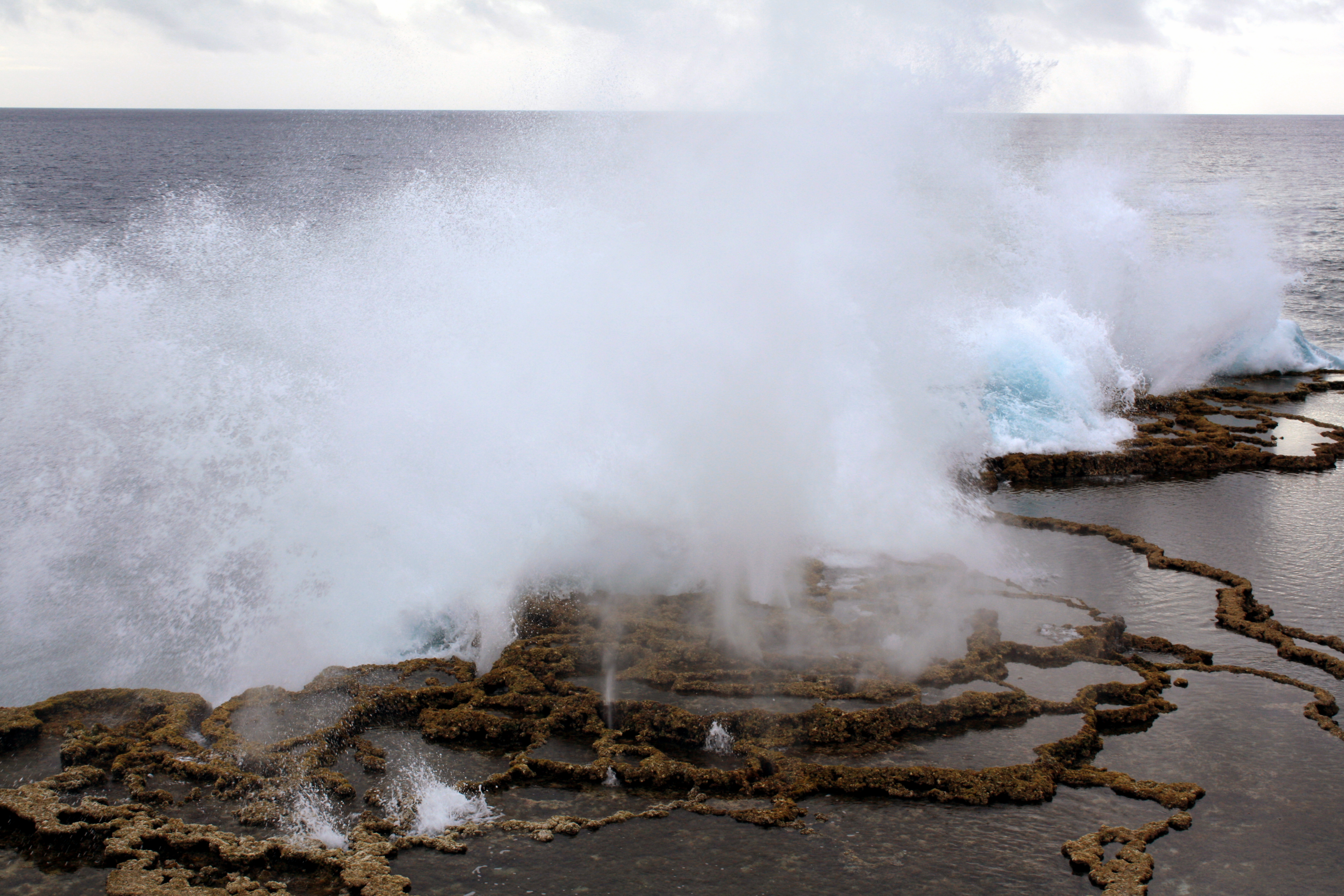
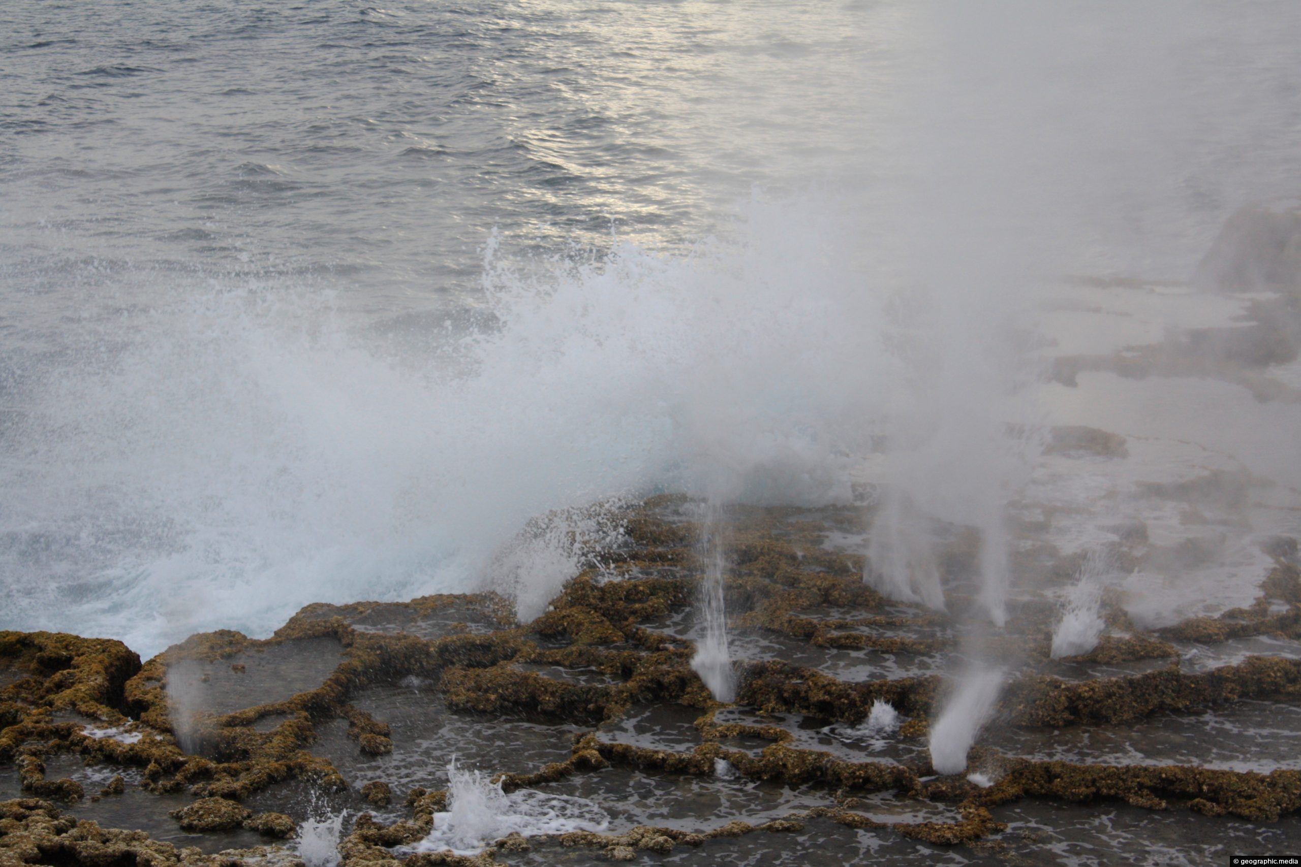
Mapu a Vaea is a 5 km (3 mi) stretch of the Tongatapu Island coastline. The surf crashes against volcanic channels where water spouts abound.
ALL / Explore Oceania / Explore Tonga / Tonga Photos / Tongatapu Island photos / Mapu a Vaea at Tongatapu Island
All original royalty-free photos, shareable maps, and informative articles.
Mapu a Vaea at Tongatapu Island
Page Views
This post has been viewed 767 times
Related Articles
-
Ha’atafu Beach on Tongatpu Island
Tongatapu Island photos, Beaches, Coral, Landscape / Horizontal, Palms, Tropics
Ha’atafu Beach is an idyllic stretch of beach and coral reef on Tongatapu Island. The coast here is a...
-
Painting on Tapa Cloth in Tonga
Tongatapu Island photos, Culture, Handicrafts, Landscape / Horizontal, People, Women
Painting on a newly created Tapa Cloth. Tapa is used as a mat or wall covering in special occasions...
-
Waves crashing at Mapu a Vaea
Tongatapu Island photos, Coral, Landscape / Horizontal, Sea
Waves crashing into a coral reef barrier at Mapu a Vaea. This part of the Tongatapu Island coastline is...
-
View of Anahulu Cave on Tongatapu Island
Tongatapu Island photos, Caves, Landscape / Horizontal
View of Anahulu Cave on the eastern side of Tongatapu Island in Tonga. The cave contains limestone caverns and...
-
Tongan men resting during the heat of the day
Tongatapu Island photos, Landscape / Horizontal, Men, People
Some Tongan men sitting down during the heat of the afternoon sun. Life here is relaxed and everyone seems...
-
Three branched Palm Tree
Tongatapu Island photos, Crops, Palms, Portrait / Vertical, Trees
This is the only palm tree in the world with three branches. Seeds have been taken from this tree...
-
Swimming in the Sea at Nukualofa Tonga
Tongatapu Island photos, Landscape / Horizontal, People, Sea
Tongans enjoying a swim in the sea near Nukualofa. The town is located on the coastline so it is...
-
Captain Cook’s Landing Place in Tongatapu Island
Tongatapu Island photos, Culture, Landscape / Horizontal, Sea
This location on the east side of Tongatpu Island is historically significant. British explorer Captain James Cook came ashore...
0 Comments
Latest Posts
Browse by Date
M | T | W | T | F | S | S |
---|---|---|---|---|---|---|
1 | 2 | 3 | 4 | 5 | ||
6 | 7 | 8 | 9 | 10 | 11 | 12 |
13 | 14 | 15 | 16 | 17 | 18 | 19 |
20 | 21 | 22 | 23 | 24 | 25 | 26 |
27 | 28 | 29 | 30 | 31 |
Popular Posts
- Awakening New Zealand video (100)
- Iguazu Falls as seen from Brazil (86)
- Metrocable Medellin (77)
- Spinnaker Hill View (68)
- Spinnaker Hill in Whitby Porirua (68)
- Pauatahanui Inlet (68)
- View from Whitby (68)
- The Devil’s Throat (62)
- Aerial View of Iguazu Falls (61)
- Porirua Harbour & Papakowhai (57)
- Lake Wakatipu (57)
- Salto Rivadavia & Iguassu River (56)
- Lake Tekapo & Lupins (54)
- Cascadas at Iguazu (53)
- Close up of Salto Rivadavia (53)
- Salto Rivadavia Misiones Province (53)
Subjects
AccommodationAnimalsArchitectureBeachesBirdsBoatsBridgesBuildingsCarsChurchesCitiesCliffsCoralCultureExtra Wide HorizontalFlowersForestsHarborsHomesIslandsLakesLandscape / HorizontalMapsMenMonumentsMountainsPalmsParksPeoplePlantsPortrait / VerticalRiversRoadsRuralSeaShopsSkyscrapersSnowSunsetsTownsTransportTreesVideosVolcanicWaterfalls
Recent Comments
- Lance on Concrete Hut Wainuiomata
- DavidJ on Concrete Hut Wainuiomata
- Tony on Concrete Hut Wainuiomata
- DavidJ on Wellington Night Skyline
- Ben on Auckland City Skyline from Westhaven Marina in 1998