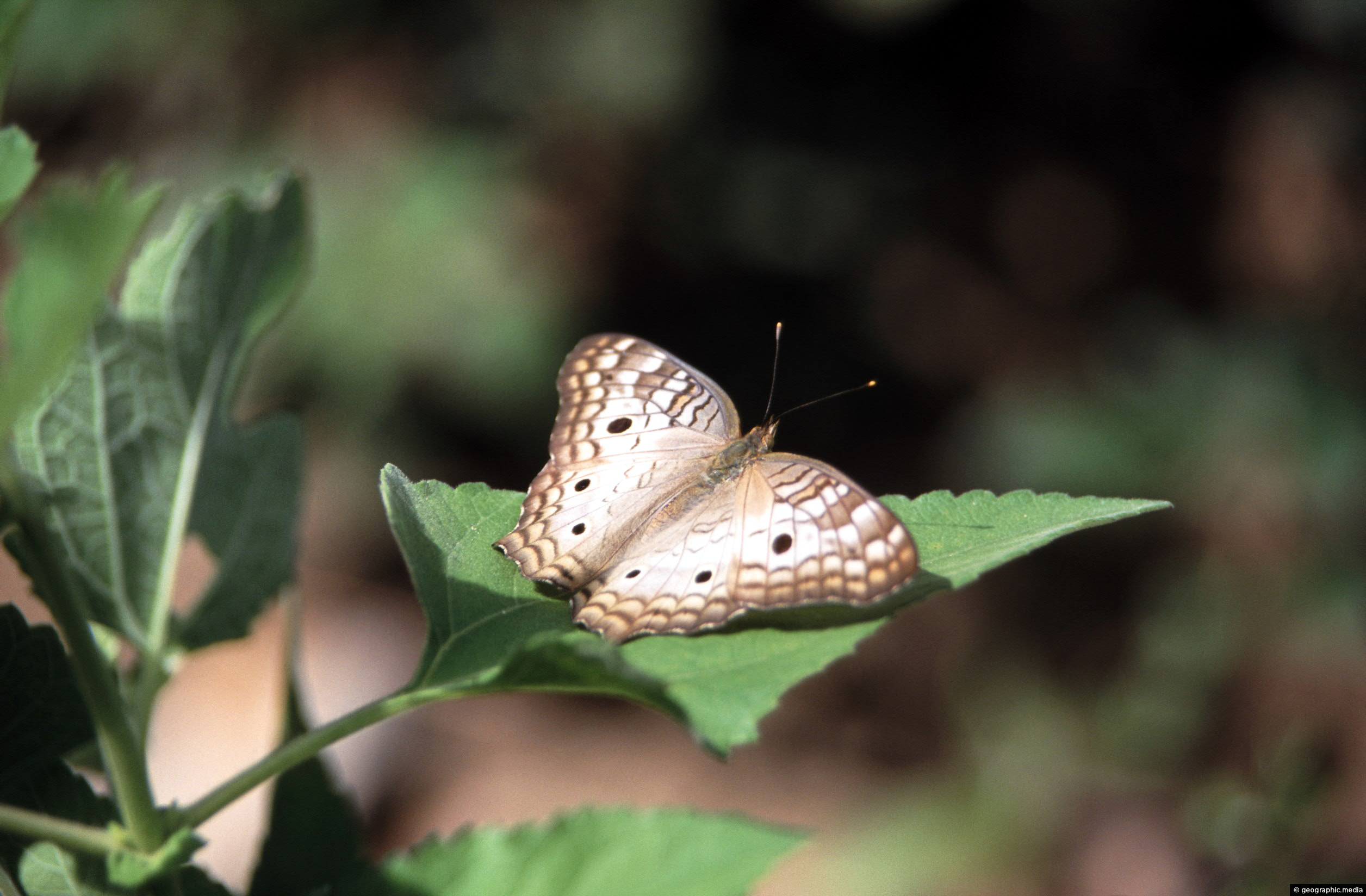
The White Peacock (Anartia jatrophae) is a species of butterfly in the Nymphalidae family. It is also known as the “Jatropha butterfly” and is found in Central and South America, including Colombia. The White Peacock is primarily white or cream-colored, with black or brown spots and stripes on its wings. It is known for its striking eye-like patterns on its wings, which are used to deter predators.
ALL / Explore South America / Explore Colombia / Colombia Photos / Anapoima photos / White Peacock (Anartia Jatrophae)
All original royalty-free photos, shareable maps, and informative articles.
White Peacock (Anartia Jatrophae)
Page Views
This post has been viewed 320 times
Related Articles
-
Banana Farm in Anapoima
Anapoima photos, Landscape / Horizontal, Rural
View of a banana farm in the hills that surround Anapoima. This area has a suitable climate and soil...
-
Carrera 2
Anapoima photos, Landscape / Horizontal, Roads
Carrera 2 is the main street in Anapoima. Carrera translates in English as race, but is closer in meaning...
-
Farmland in Anapoima Colombia
Anapoima photos, Landscape / Horizontal, Rural
Anapoima is located among farmland near the city of Bogota. At an altitude of 700 meters above sea level,...
-
Útiles Papelería y Miscelánea Anapoima
Anapoima photos, Buildings, Landscape / Horizontal
Útiles Papelería y Miscelánea in ANapoima provides stationary and miscellaneous items that are commonly used in offices, schools and...
-
Farms in Anapoima
Anapoima photos, Landscape / Horizontal, Rural
Farming is an important industry in the municipality of Anapoima, Colombia. The area is known for its agricultural production,...
-
Anapoima Town
Anapoima photos, Landscape / Horizontal, Rural, Towns
Looking at the town of Anapoima from the surrounding countryside and forest. The town is located on the flanks...
-
Anapoima Children
Anapoima photos, Children, Landscape / Horizontal, People
Two children from Anapoima in Colombia posing for a photo.
-
Rural Anapoima
Anapoima photos, Landscape / Horizontal, Rural
View of rural countryside just outside the town of Anapoima. The land is used for farming and crops. Above...
0 Comments
Calendar
M | T | W | T | F | S | S |
---|---|---|---|---|---|---|
1 | 2 | 3 | 4 | |||
5 | 6 | 7 | 8 | 9 | 10 | 11 |
12 | 13 | 14 | 15 | 16 | 17 | 18 |
19 | 20 | 21 | 22 | 23 | 24 | 25 |
26 | 27 | 28 | 29 | 30 | 31 |
Popular Posts
- Awakening New Zealand video (100)
- Iguazu Falls as seen from Brazil (87)
- Metrocable Medellin (78)
- Pauatahanui Inlet (69)
- Spinnaker Hill View (68)
- Spinnaker Hill in Whitby Porirua (68)
- View from Whitby (68)
- The Devil’s Throat (62)
- Aerial View of Iguazu Falls (61)
- Porirua Harbour & Papakowhai (57)
- Lake Wakatipu (57)
- Salto Rivadavia & Iguassu River (56)
- Lake Tekapo & Lupins (54)
- Nelson View (53)
- Salto Rivadavia Misiones Province (53)
- Cascadas at Iguazu (53)
Subjects
AccommodationAnimalsArchitectureBeachesBirdsBoatsBridgesBuildingsCarsChurchesCitiesCoralCultureExtra Wide HorizontalFlowersForestsHarborsHomesIslandsLakesLandscape / HorizontalMapsMenMonumentsMountainsPalmsParksPeoplePlantsPortrait / VerticalRiversRoadsRuralSeaShopsSkyscrapersSnowSunsetsTownsTrailsTransportTreesVideosVolcanicWaterfalls
Recent Comments
- Lance on Concrete Hut Wainuiomata
- Tony on Concrete Hut Wainuiomata
- DavidJ on Wellington Night Skyline
- Ben on Auckland City Skyline from Westhaven Marina in 1998
- Ben on Auckland Harbour Bridge view