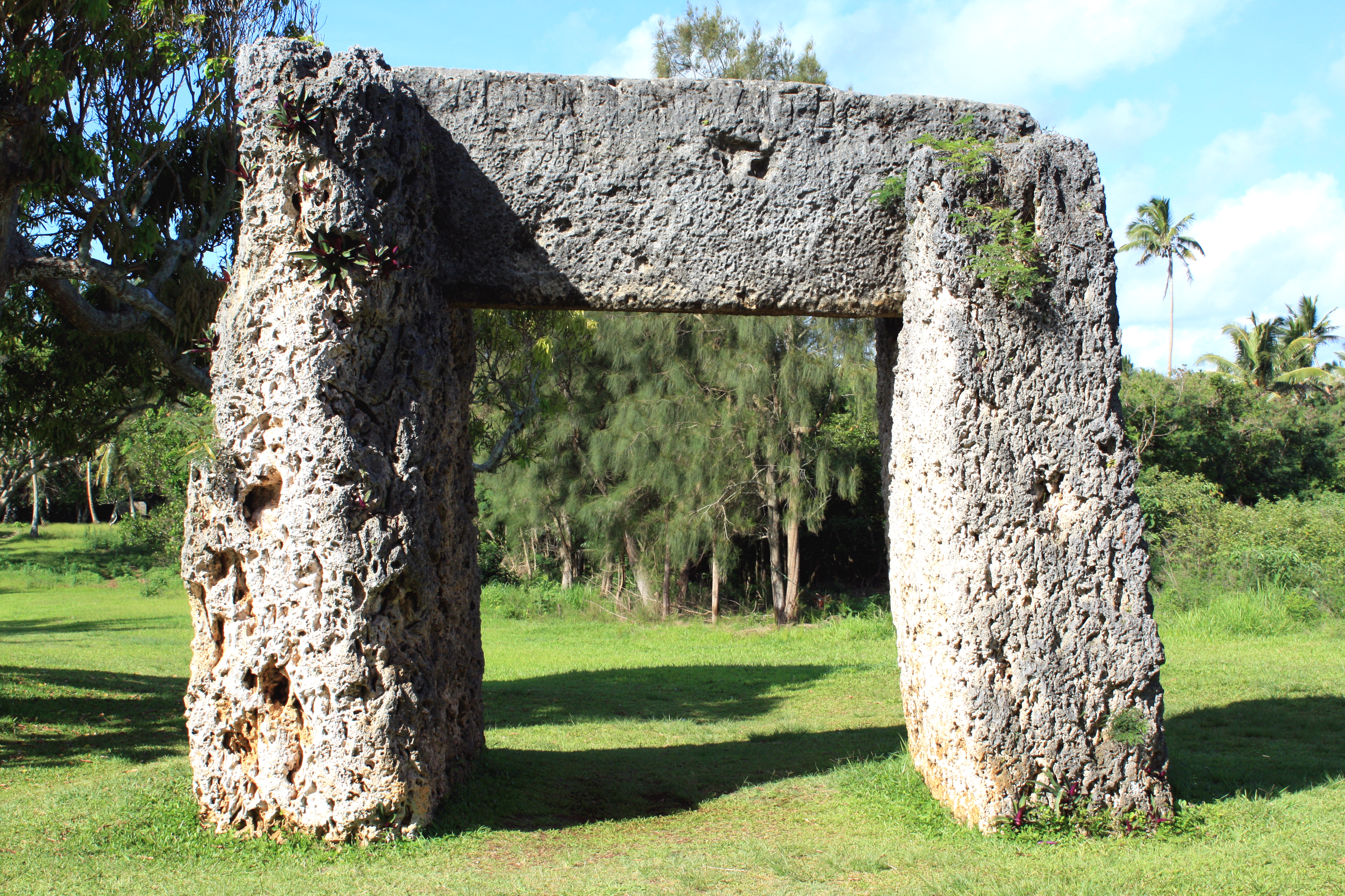
The Trilithon (Ha’amonga ‘a Maui) is a historically significant stone archway in Tonga. Dubbed the Stonehenge of the Pacific, it is located at the northern end of Tongatapu Island. It’s estimated weight is around 40 tons which consists of three giant coral stones. The structure was constructed sometime in the 13th century by King Tu’i Tonga Tu’itatui. Theories abound as to the function of the archway, with the most popular belief being a gateway to some royal gardens. Another theory suggests it has astronomical significance as the structure is positioned with a north and south orientation with the horizontal stone containing a V shaped mark which roughly points in the direction of the solstice.
ALL / Explore Oceania / Explore Tonga / Tonga Photos / Tongatapu Island photos / The Trilithon on Tongatapu Island
All original royalty-free photos, shareable maps, and informative articles.
The Trilithon on Tongatapu Island
Page Views
This post has been viewed 1,300 times
Related Articles
-
Palm Trees on Tongatapu Island
Tongatapu Island photos, Landscape / Horizontal, Palms, Trees
Looking at a grove of palm trees on Tongatapu Island in Tonga. Palm trees are a crop in Tonga,...
-
Swimming in the Sea at Nukualofa Tonga
Tongatapu Island photos, Landscape / Horizontal, People, Sea
Tongans enjoying a swim in the sea near Nukualofa. The town is located on the coastline so it is...
-
View of Anahulu Cave on Tongatapu Island
Tongatapu Island photos, Caves, Landscape / Horizontal
View of Anahulu Cave on the eastern side of Tongatapu Island in Tonga. The cave contains limestone caverns and...
-
Waves crashing at Mapu a Vaea
Tongatapu Island photos, Coral, Landscape / Horizontal, Sea
Waves crashing into a coral reef barrier at Mapu a Vaea. This part of the Tongatapu Island coastline is...
-
Local Church in a small settlement on Tongatapu
Tongatapu Island photos, Buildings, Churches, Landscape / Horizontal
Looking at a colorful local church building in a small settlement on the island of Tongatapu in Tonga.
-
Captain Cook’s Landing Place in Tongatapu Island
Tongatapu Island photos, Culture, Landscape / Horizontal, Sea
This location on the east side of Tongatpu Island is historically significant. British explorer Captain James Cook came ashore...
-
Mapu a Vaea at Tongatapu Island
Tongatapu Island photos, Beaches, Landscape / Horizontal, Sea
Mapu a Vaea is a 5 km (3 mi) stretch of the Tongatapu Island coastline. The surf crashes against...
-
Painting on Tapa Cloth in Tonga
Tongatapu Island photos, Culture, Handicrafts, Landscape / Horizontal, People, Women
Painting on a newly created Tapa Cloth. Tapa is used as a mat or wall covering in special occasions...
0 Comments
Calendar
M | T | W | T | F | S | S |
---|---|---|---|---|---|---|
1 | 2 | |||||
3 | 4 | 5 | 6 | 7 | 8 | 9 |
10 | 11 | 12 | 13 | 14 | 15 | 16 |
17 | 18 | 19 | 20 | 21 | 22 | 23 |
24 | 25 | 26 | 27 | 28 | 29 | 30 |
31 |
Popular Posts
- Awakening New Zealand video (100)
- Iguazu Falls as seen from Brazil (87)
- Metrocable Medellin (78)
- Pauatahanui Inlet (69)
- Spinnaker Hill in Whitby Porirua (68)
- Spinnaker Hill View (68)
- View from Whitby (68)
- The Devil’s Throat (62)
- Aerial View of Iguazu Falls (61)
- Porirua Harbour & Papakowhai (57)
- Lake Wakatipu (57)
- Salto Rivadavia & Iguassu River (56)
- Lake Tekapo & Lupins (54)
- Nelson View (53)
- Salto Rivadavia Misiones Province (53)
- Cascadas at Iguazu (53)
Subjects
AccommodationAnimalsArchitectureBeachesBirdsBoatsBridgesBuildingsCarsChurchesCitiesCoralCultureExtra Wide HorizontalFlowersForestsHarborsHomesIslandsLakesLandscape / HorizontalMapsMenMonumentsMountainsPalmsParksPeoplePlantsPortrait / VerticalRiversRoadsRuralSeaShopsSkyscrapersSnowSunsetsTownsTrailsTransportTreesVideosVolcanicWaterfalls
Recent Comments
- Lance on Concrete Hut Wainuiomata
- Tony on Concrete Hut Wainuiomata
- DavidJ on Wellington Night Skyline
- Ben on Auckland City Skyline from Westhaven Marina in 1998
- Ben on Auckland Harbour Bridge view