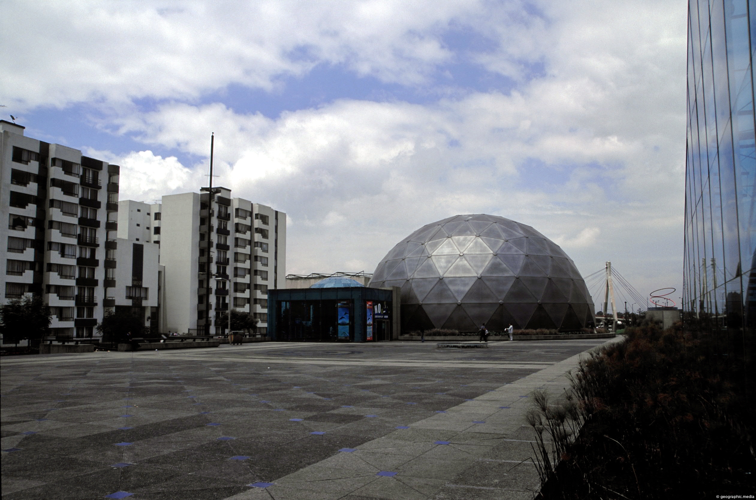
Maloka Museum in Bogota is an interactive science museum located in the suburb of Ciudad Salitre. It includes exhibits based on both science and technology. In view is both the Maloka Plaza and Maloka Dome Theater.
ALL / Explore South America / Explore Colombia / Colombia Photos / Bogota photos / Maloka Museum in Bogota Colombia
All original royalty-free photos, shareable maps, and informative articles.
Maloka Museum in Bogota Colombia
Page Views
This post has been viewed 4,116 times
Related Articles
-
Crepes & Waffles in Calle 93 Bogota
Bogota photos, Landscape / Horizontal, Men, People, Roads, Shops, Women
View of Crepes & Waffles a popular franchised restaurant found throughout Colombia. This one is located in Calle 93...
-
Maloka Museum Entrance in Bogota
Bogota photos, Architecture, Buildings, Landscape / Horizontal
View of the glass entrance to Maloka Museum in Bogota. It leads under the Maloka plaza and connects to...
-
Bogota View from Eastern Hills
Bogota photos, Buildings, Cities, Landscape / Horizontal
View of Bogota in Colombia from the eastern hills. The city sits atop a high plateau on the Andes...
-
Strata Three Bogota
Bogota photos, Buildings, Landscape / Horizontal, Restaurant
A typical street in Bogota within with a strata three classification. The strata system is used for determining public...
-
Andes Bogota Colombia
Bogota photos, Cities, Landscape / Horizontal, Mountains, Plants
Looking at the city of Bogota from the eastern peaks of the Andes which rise just over 3000 metres...
-
Bogota Skyline (circa 2002)
Bogota photos, Buildings, Cities, Portrait / Vertical, Roads, Skyscrapers
The skyline of Bogotá in 2002, was a mix of old and newer architecture. Since then, the city has...
-
Eastern View of Bogota from CBD
Bogota photos, Buildings, Cities, Landscape / Horizontal
Looking east from the central CBD of Bogota with part of the CBD in view. In view are some...
-
Bogota Canals
Bogota photos, Landscape / Horizontal, Parks, Rivers, Trees
Bogota city in Colombia has a network of canals that for part of the city’s drainage system. Some canals...
0 Comments
Calendar
M | T | W | T | F | S | S |
---|---|---|---|---|---|---|
1 | 2 | 3 | 4 | |||
5 | 6 | 7 | 8 | 9 | 10 | 11 |
12 | 13 | 14 | 15 | 16 | 17 | 18 |
19 | 20 | 21 | 22 | 23 | 24 | 25 |
26 | 27 | 28 | 29 | 30 | 31 |
Popular Posts
- Awakening New Zealand video (100)
- Iguazu Falls as seen from Brazil (87)
- Metrocable Medellin (78)
- Pauatahanui Inlet (69)
- Spinnaker Hill in Whitby Porirua (68)
- Spinnaker Hill View (68)
- View from Whitby (68)
- The Devil’s Throat (62)
- Aerial View of Iguazu Falls (61)
- Porirua Harbour & Papakowhai (57)
- Lake Wakatipu (57)
- Salto Rivadavia & Iguassu River (56)
- Lake Tekapo & Lupins (54)
- Nelson View (53)
- Salto Rivadavia Misiones Province (53)
- Cascadas at Iguazu (53)
Subjects
AccommodationAnimalsArchitectureBeachesBirdsBoatsBridgesBuildingsCarsChurchesCitiesCoralCultureExtra Wide HorizontalFlowersForestsHarborsHomesIslandsLakesLandscape / HorizontalMapsMenMonumentsMountainsPalmsParksPeoplePlantsPortrait / VerticalRiversRoadsRuralSeaShopsSkyscrapersSnowSunsetsTownsTrailsTransportTreesVideosVolcanicWaterfalls
Recent Comments
- Lance on Concrete Hut Wainuiomata
- Tony on Concrete Hut Wainuiomata
- DavidJ on Wellington Night Skyline
- Ben on Auckland City Skyline from Westhaven Marina in 1998
- Ben on Auckland Harbour Bridge view